2026-05-06 · 3 min read · Musky Lakes
Rivers Now Trace the Water on Musky Lakes
River pages are getting a big upgrade: traced centerlines now follow the actual musky corridor, and St. Croix is leading the push toward better launch coverage along long river reaches.
River pages needed to stop behaving like lakes
For a long time, river entries on Musky Lakes inherited the same map behavior as lake pages: one point, one centered view, and not much help when the water actually stretched for miles. That worked well enough to get river fisheries listed, but it did not match how anglers think about rivers or how rivers actually fish.
Now supported river pages can trace the river itself. Instead of dropping you onto a generic center point, the map can draw the musky-relevant river corridor so you see the shape of the water, the direction of the reach, and the scale of the system right away.
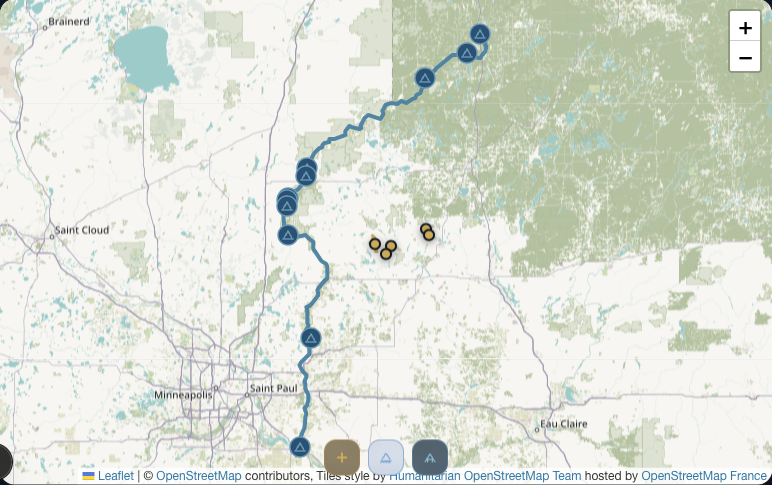
St. Croix is the easiest example to understand
The St. Croix River in Minnesota is a good reminder of why this matters. A river like that is not a small round target. It is a long, connected musky corridor where a single midpoint does not tell the real story.
That is exactly the direction the river upgrade is fixing across Musky Lakes. On traced river pages, the map follows the water instead of pretending the fishery lives at one dot. St. Croix is the kind of river that makes the value obvious immediately.
The next step is landings that follow the river too
Tracing the river is only part of the improvement. We are also working toward adding boat landings in a way that makes sense for long river systems, so launch options are spread along the actual musky reach instead of being tied only to a nearby centroid.
That matters because rivers break normal lake logic. A useful launch might be many miles upstream or downstream, and a plain distance check can accidentally favor inland access that is close to the page point but not actually the best river entry. The goal is launch coverage that behaves like the river behaves.
St. Croix is also the pilot for launch coverage
The St. Croix corridor is already helping shape that rollout. It is one of the clearest examples in the project because the river is long, obvious on the map, and a perfect fit for distributing access points along the traced reach instead of clustering everything near one location.
That is where Musky Lakes is heading with river pages: first show the river as a river, then build out the planning layer around it with better launches and access context. It is a simple upgrade on the surface, but it makes the map much more honest and much more useful for anglers trying to break down real musky water.